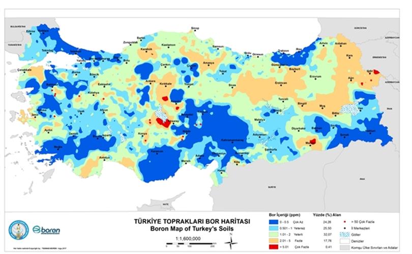
In cooperation with the National Boron Institute, the Center for Soil Fertilizers and Water Resources Research Institute and the Boron Map, the Boron State Detection and Mapping Project of the Turkish soil was prepared and the project final report was prepared in 2010. In the study carried out nationwide, 0-30 cm and additionally partly 30-60 cm. A total of 7758 soil samples taken from the depths were used as material. In the study, boron scales at different levels of soil were determined with the aid of georeferenced soil sampling at the country level and the spatial distributions of these levels were determined by geo-statistical methods and presented on the map. This map, which is produced as a result of the work, has been updated with a total of 15396 soil samples and Ordinary Kriging method.
Sample points and neighborhood were studied in the study and samples with a boron sample of 50 ppm were included in the geostatistical model. The boron values of sample 14 are quite high between 50-7461 ppm. For this reason, samples with large boron values of 50 cm were excluded due to possible faults due to the superficial integrity of the model to be produced, and these points were regarded as point "hot spots" on the map and integrated into the result map. In the production of the boron map, the Anatolian side and Trakya side were separately modeled and verified with separate parametric iterations. The updated Turkey Land Pipeline Map allows for the assessment of general objectives in the field, which are allowed in the map scale, in areas containing boron deficiency or toxic levels of boron. It will also help to plan boron fertilizer programs supported by local soil analysis when a specific area is concerned.
